
A RECENTLY submitted letter to the Beacon has prompted a look into the history along the River Monnow in Monmouth.
The 17th July edition of the Beacon featured a picture of a bridge carrying traffic over the Monnow, before the construction of the A40. This prompted a letter from reader Gerald Richardson asking about the history of the area.
The road was built up above the flood plain across Chippenham and the store on the left was called Thomas’ Turnpike Stores near Beech Road, with a reputation for having particularly delicious ice cream, according to Monmouth resident Jeff Webb.
The bridge likely dates back to the First World War or earlier and is on the route of the 19th century turnpike road. It’s almost certain to have been the first bridge over that part of the river as we know it, since the Monnow in Monmouth has a rather unusual history.


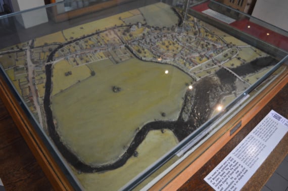
Before the 1850s the River Monnow took a significantly different route through the town than it does today. It previously broke away from Cinderhill Street and cut north-easterly through, what we know today, as the Monmouth allotments and entering the River Wye further upstream, according to Steve Clarke, chairman of the Monmouth Archaeological Society.
Due to a series of floods in the 1850s a working group was formed to address the issue and the Monnow was rerouted to the direction we now recognise today in a project known as the Monnow Cutting. The bed where the river once ran was used as the town dump before being made part of what was then the Chippenham Race Ground. It had been suspected that the prospect of extending the race ground was a contributing factor to the decision.
Flooding in Monmouth was worsened by the old route of the river as it entered into the Wye against the current. The old route of the River Monnow can be seen on the model map in the Monmouth Museum.
In 1856 around 35 men began digging a path for the new route. Three months into the construction there was a flood which many believed would have been much worse if it hadn’t been for the works in progress, even though they were incomplete at the time, with the then-Beacon editor commenting: "The advantages of the Monnow Cutting have clearly been seen."
Evidence of this can be seen today in the area now used for allotments where there is a division in the soil with Chippenham mud on one side and a more stony soil on the other.
While the new route of the river had expanded the town, the construction of the dual carriageway had in turn restricted it, reducing the size of the Chippenham Playing Fields and separating the area now used for allotments from the town.
Comments
This article has no comments yet. Be the first to leave a comment.